A Horizon
A mineral soil horizon that formed at the surface or below an O horizon where organic material is accumulating. See Soil Taxonomy (Soil Survey Staff, 1999) for a complete definition.
Accreting areas
Landscape positions in which soil material accumulates through deposition from higher elevations or upstream positions more rapidly than the rate at which soil material is being lost through erosion.
Anaerobic
A condition in which molecular oxygen is virtually absent from the soil.
Anaerobiosis
Microbiological activity under anaerobic conditions.
Aquic conditions
Conditions in the soil represented by depth of saturation, occurrence of reduction, and redoximorphic features. See Soil Taxonomy (Soil Survey Staff, 1999) for a complete definition.
Artificial drainage
The use of human efforts and devices to remove free water from the soil surface or from the soil profile. The hydrology may also be modified by levees and dams, which keep water from entering a site.
CaCO3 equivalent
The acid neutralizing capacity of a soil expressed as a weight percentage of CaCO3 (molecular weight of CaCO3 equals 100).
Calcic horizon
An illuvial horizon in which carbonates have accumulated to a significant extent. See Soil Taxonomy (Soil Survey Staff, 1999) for a complete definition.
Calcium carbonate
Calcium carbonate has the chemical formula of CaCO3. It effervesces when treated with cold hydrochloric acid.
Closed depressions
Low-lying areas that are surrounded by higher ground and have no natural outlet for surface drainage.
COE
U.S. Army Corps of Engineers.
Common
When referring to redox concentrations and/or depletions, “common” represents 2 to 20 percent of the observed surface.
Concave landscapes
Landscapes in which the surface curves downward.
Depleted matrix
For loamy and clayey material (and sandy material in areas of indicators A11 and A12), a depleted matrix refers to the volume of a soil horizon or subhorizon in which the processes of reduction and translocation have removed or transformed iron, creating colors of low chroma and high value. A, E, and calcic horizons may have low chromas and high values and may therefore be mistaken for a depleted matrix; however, they are excluded from the concept of depleted matrix unless the soil has common or many distinct or prominent redox concentrations occurring as soft masses or pore linings. In some areas the depleted matrix may change color upon exposure to air (see Reduced matrix); this phenomenon is included in the concept of depleted matrix. The following combinations of value and chroma identify a depleted matrix:
1. Matrix value of 5 or more and chroma of 1 or less with or without redox concentrations occurring as soft masses and/or pore linings; or
2. Matrix value of 6 or more and chroma of 2 or less with or without redox concentrations occurring as soft masses and/or pore linings; or
3. Matrix value of 4 or 5 and chroma of 2 and 2 percent or more distinct or prominent redox concentrations occurring as soft masses and/or pore linings; or
4. Matrix value of 4 and chroma of 1 and 2 percent or more distinct or prominent redox concentrations occurring as soft masses and/or pore linings.
Diffuse boundary
Used to describe redoximorphic features that grade gradually from one color to another. The color grade is commonly more than 2 mm wide. “Clear” is used to describe boundary color gradations intermediate between sharp and diffuse.
Distinct
Readily seen but contrasting only moderately with the color to which compared.
The contrast is distinct if:
1. Delta hue = 0, then
a) Delta value <2 and delta chroma >1 to <4, or
b) Delta value >2 to <4 and delta chroma <4.
2. Delta hue = 1, then
a) Delta value <1 and delta chroma >1 to <3, or
b) Delta value >1 to <3 and delta chroma <3.
3. Delta hue = 2, then
a) Delta value = 0 and delta chroma >0 to <2, or
b) Delta value >0 to <2 and delta chroma <2.
Regardless of the magnitude of hue difference, where both colors have value <3 and chroma <2, the contrast is faint.
E horizon
A mineral horizon in which the dominant process is loss of silicate clay, iron, and/or aluminum, leaving a concentration of sand and silt particles. See Soil Taxonomy (Soil Survey Staff, 1999) for a complete definition.
EPA
U.S. Environmental Protection Agency.
Epipedon
A horizon that has developed at the soil surface. See Soil Taxonomy (Soil Survey Staff, 1999) for a complete definition.
Faint
Evident only on close examination. The contrast is faint if:
1. Delta hue = 0, then delta value <2 and delta chroma <1, or
2. Delta hue = 1, then delta value <1 and delta chroma <1, or
3. Delta hue = 2, then delta value = 0 and delta chroma = 0, or
Any delta hue if both colors have value <3 and chroma <2.
Fe-Mn concretions
Firm to extremely firm, irregularly shaped bodies with sharp to diffuse boundaries. When broken in half, concretions have concentric layers. See Vepraskas (1994) for a complete discussion.
Fe-Mn nodules
Firm to extremely firm, irregularly shaped bodies with sharp to diffuse boundaries. When broken in half, nodules do not have visibly organized internal structure. See Vepraskas (1994) for a complete discussion.
Few
When referring to redox concentrations and/or depletions, “few” represents less than 2 percent of the observed surface.
Fibric
See Peat.
Flood plain
The nearly level plain that borders a stream and is subject to inundation under flood-stage conditions unless protected artificially. It is usually a constructional landform built of sediment deposited during overflow and lateral migration of the streams.
Fragmental soil material
Soil material that consists of 90 percent or more rock fragments. Less than 10 percent of the soil consists of particles 2 mm or smaller.
Frequently flooded or ponded
A frequency class in which flooding or ponding is likely to occur often under usual weather conditions (a chance of more than 50 percent in any year, or more than 50 times in 100 years).
FWS
U.S. Department of the Interior, Fish and Wildlife Service.
g
A horizon suffix indicating that the horizon is gray because of wetness but not necessarily that it is gleyed. All gleyed matrices (defined below) should have the suffix “g”; however, not all horizons with the “g” suffix are gleyed. For example, a horizon with the color 10YR 6/2 that is at least seasonally wet, with or without other redoximorphic features, should have the “g”suffix.
Glauconitic
Refers to a mineral aggregate that contains a micaceous mineral resulting in a characteristic green color, e.g., glauconitic shale or clay.
Gleyed matrix
Soils with a gleyed matrix have the following combinations of hue, value, and chroma (the soils are not glauconitic):
1. 10Y, 5GY, 10GY, 10G, 5BG, 10BG, 5B, 10B, or 5PB with value of 4 or more and chroma of 1; or
2. 5G with value of 4 or more and chroma of 1 or 2; or
3. N with value of 4 or more; or
In some places the gleyed matrix may change color upon exposure to air. (See Reduced matrix). This phenomenon is included in the concept of gleyed matrix.
Hemic
See Mucky peat.
Histels
Organic soils that overlie permafrost and show evidence of cryoturbation. See Soil Taxonomy (Soil Survey Staff, 1999) for a complete definition.
Histic epipedon
A thick (20- to 60-cm, or 8- to 24- inch) organic soil horizon that is saturated with water at some period of the year (unless the soil is artificially drained) and that is at or near the surface of a mineral soil.
Histosols
Organic soils that have organic soil materials in more than half of the upper 80 cm (32 inches) or that have organic materials of any thickness if they overlie rock or fragmental materials that have interstices filled with organic soil materials. See Soil Taxonomy (Soil Survey Staff, 1999) for a complete definition.
Horizon
A layer, approximately parallel to the surface of the soil, distinguishable from adjacent layers by a distinctive set of properties produced by soil-forming processes. See Soil Taxonomy (Soil Survey Staff, 1999) for a complete definition.
Hydric soil definition (1994)
A soil that formed under conditions of saturation, flooding, or ponding long enough during the growing season to develop anaerobic conditions in the upper part.
Hydrogen sulfide odor
The odor of H2S. It is similar to the smell of rotten eggs.
Hydromorphic features
Features in the soil caused or formed by water.
Layer(s)
A horizon, subhorizon, or combination of contiguous horizons or subhorizons sharing at least one property referred to in the indicators.
Lithologic discontinuity
Occurs in a soil that has developed in more than one type of parent material. Commonly determined by a significant change in particle-size distribution, mineralogy, etc. that indicates a difference in material from which the horizons formed.
LRR
Land resource region. LRRs are geographic areas characterized by a particular pattern of soils, climate, water resources, and land use. Each LRR is assigned a different letter of the alphabet (A-Z). LRRs are defined in U.S. Department of Agriculture Handbook 296 (USDA, NRCS, 2006b).
Many
When referring to redox concentrations and/or depletions, “many” represents more than 20 percent of the observed surface.
Marl
An earthy, unconsolidated deposit consisting chiefly of calcium carbonate mixed with clay in approximately equal proportions; formed primarily under freshwater lacustrine conditions. See Soil Taxonomy (Soil Survey Staff, 1999) for a complete definition.
Masked
Through redoximorphic processes, the color of soil particles is hidden by organic material, silicate clay, iron, aluminum, or some combination of these.
Matrix
The dominant soil volume that is continuous in appearance and envelops microsites. When three colors occur, such as when a matrix, depletions, and concentrations are present, the matrix may represent less than 50 percent of the total soil volume.
MLRA
Major land resource areas. MLRAs are geographically associated divisions of land resource regions. MLRAs are defined in U.S. Department of Agriculture Handbook 296 (USDA, NRCS, 2006b).
Mollic epipedon
A mineral surface horizon that is relatively thick, dark colored, and humus rich and has high base saturation. See Soil Taxonomy (Soil Survey Staff, 1999) for a complete definition.
Mollisols
Mineral soils that have a mollic epipedon. See Soil Taxonomy (Soil Survey Staff, 1999) for a complete definition.
Muck
Sapric organic soil material in which virtually all of the organic material is so decomposed that identification of plant forms is not possible. Bulk density is normally 0.2 or more. Muck has less than one-sixth fibers after rubbing, and its sodium pyrophosphate solution extract color has lower value and chroma than 5/1, 6/2, and 7/3.
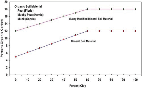
Mucky modified mineral soil material
A USDA soil texture modifier, e.g., mucky sand. Mucky modified mineral soil material that has 0 percent clay has between 5 and 12 percent organic carbon. Mucky modified mineral soil material that has 60 percent clay has between 12 and 18 percent organic carbon. Soils with an intermediate amount of clay have intermediate amounts of organic carbon. Where the organic component is peat (fibric material) or mucky peat (hemic material), mucky mineral soil material does not occur.
Mucky peat
Hemic organic material, which is characterized by decomposition that is intermediate between that of fibric material and that of sapric material. Bulk density is normally between 0.1 and 0.2 g/cm3. Mucky peat does not meet the fiber content (after rubbing) or sodium pyrophosphate solution extract color requirements for either fibric or sapric soil material.
Nodules
See Fe-Mn nodules.
NRCS
USDA, Natural Resources Conservation Service (formerly Soil Conservation Service).
NTCHS
National Technical Committee for Hydric Soils.
Organic matter
Plant and animal residue in the soil in various stages of decomposition.
Organic soil material
Soil material that is saturated with water for long periods or artificially drained and, excluding live roots, has 18 percent or more organic carbon with 60 percent or more clay or 12 percent or more organic carbon with 0 percent clay. Soils with an intermediate amount of clay have an intermediate amount of organic carbon. If the soil is never saturated for more than a few days, it contains 20 percent or more organic carbon. Organic soil material includes muck, mucky peat, and peat.
Peat
Fibric organic soil material. The plant forms can be identified in virtually all of the organic material. Bulk density is normally <0.1. Peat has three-fourths or more fibers after rubbing, or it has two-fifths or more fibers after rubbing and has sodium pyrophosphate solution extract color of 7/1, 7/2, 8/2, or 8/3.
Plinthite
The sesquioxide-rich, humus-poor, highly weathered mixture of clay with quartz and other diluents. See Soil Taxonomy (Soil Survey Staff, 1999) for a complete discussion.
Ponding
Standing water in a closed depression that is removed only by percolation, evaporation, or transpiration. The ponding lasts for more than 7 days.
Pore linings
Zones of accumulation that may be either coatings on a ped or pore surface or impregnations of the matrix adjacent to the pore or ped. See Vepraskas (1994) for a complete discussion.
Prominent
Contrasts strongly in color. Color contrasts more contrasting than faint and distinct are prominent.
Red parent material
The parent material with a natural inherent reddish color attributable to the presence of iron oxides, typically hematite (Elless and Rabenhorst, 1994; Elless et al., 1996), occurring as coatings on and occluded within mineral grains. Soils that formed in red parent material have conditions that greatly retard the development and extent of the redoximorphic features that normally occur under prolonged aquic conditions. They typically have a Color Change Propensity Index (CCPI) of <30 (Rabenhorst and Parikh, 2000). Most commonly, the material consists of dark red, consolidated Mesozoic or Paleozoic sedimentary rocks, such as shale, siltstone, and sandstone, or alluvial materials derived from such rocks. Assistance from a local soil scientist may be needed to determine where red parent material occurs.
Redox concentrations
Bodies of apparent accumulation of Fe-Mn oxides. Redox concentrations include soft masses, pore linings, nodules, and concretions. For the purposes of the indicators, nodules and concretions are excluded from the concept of redox concentrations unless otherwise specified by specific indicators. See Vepraskas (1994) for a complete discussion.
Redox depletions
Bodies of low chroma (2 or less) having value of 4 or more where Fe-Mn oxides have been stripped or where both Fe-Mn oxides and clay have been stripped. Redox depletions contrast distinctly or prominently with the matrix. See Vepraskas (1994) for a complete discussion.
Redoximorphic features
Features formed by the processes of reduction, translocation, and/or oxidation of Fe and Mn oxides; formerly called mottles and low-chroma colors. See Vepraskas (1994) for a complete discussion.
Reduced matrix
A soil matrix that has low chroma and high value, but in which the color changes in hue or chroma when the soil is exposed to air. See Vepraskas (1994) for a complete discussion.
Reduction
For the purpose of the indicators, reduction occurs when the redox potential (Eh) is below the ferric-ferrous iron threshold as adjusted for pH. In hydric soils, this is the point when the transformation of ferric iron (Fe3+) to ferrous iron (Fe2+) occurs.
Relict features
Soil morphological features that reflect past hydrologic conditions of saturation and anaerobiosis. See Vepraskas (1994) for a complete discussion.
Sapric
See Muck.
Saturation
Wetness characterized by zero or positive pressure of the soil water. Almost all of the soil pores are filled with water.
Sharp boundary
Used to describe redoximorphic features that grade sharply from one color to another. The color grade is commonly less than 0.1 mm wide.
Soft masses
Noncemented redox concentrations, frequently within the soil matrix, that are of various shapes and cannot be removed as discrete units.
Soil texture
The relative proportions, by weight, of sand, silt, and clay particles in the soil material less than 2 mm in size.
Spodic horizon
A mineral soil horizon that is characterized by the illuvial accumulation of amorphous materials consisting of aluminum and organic carbon with or without iron. The spodic horizon has a minimum thickness, a minimum quantity of oxalate extractable carbon plus aluminum, and/or specific color requirements.
Stream terrace
One, or a series of flat-topped landforms in a stream valley that flank and are parallel to the stream channel, originally formed by a previous stream level, and representing remnants of an abandoned flood plain, stream bed, or valley floor produced during a past state of fluvial erosion or deposition (i.e., currently very rarely or never flooded; inactive cut and fill and/or scour and fill processes). Erosional surfaces cut into bedrock and thinly mantled with stream deposits (alluvium) are called “strath terraces.” Remnants of constructional valley floors thickly mantled with alluvium are called alluvial terraces.
Umbric epipedon
A thick, dark mineral surface horizon with base saturation of less than 50 percent. See Soil Taxonomy (Soil Survey Staff, 1999) for a complete definition.
Vertisol
A mineral soil with 30 percent or more clay in all layers. These soils expand and shrink, depending on moisture content, and have slickensides or wedge-shaped peds. See Soil Taxonomy (Soil Survey Staff, 1999) for a complete definition.
Wetland
An area that has hydrophytic vegetation, hydric soils, and wetland hydrology, as per the “National Food Security Act Manual” and the 1987 Corps of Engineers Wetlands Delineation Manual (United States Army Corps of Engineers, 1987).
Within
When referring to specific indicator depth requirements, “within” means not beyond in depth. “Within a depth of 15 cm,” for example, indicates that the depth is less than or equal to 15 cm.